I’ve done my best over the last three days to not even look at the weather models. I give my self a C+ for that effort. At least once a day I did take a peak at the GFS ensemble run for total snowfall over the next 16 days looking to see if snow is still in our future. The good news is that it is still there. The bad news is that it’s going to arrive later than we like.
I’ve mentioned a few times in the last month that we need a drastic pattern change, not an incremental one. That RRR is going to hold in a bit stronger than we would like. The models are in pretty good agreement that the ridge will get get pushed a bit south at first, resulting in a zonal flow for the next week to ten days. That means we will see the moisture, but not get a lot of supporting cold air that brings us snowfall. Sometime around Christmas we see a bit more of a trough moving in that could bring the cold air and snow. Here’s the three major ensemble runs for pressure anomalies:


That’s some decent model agreement, at least in terms of a zonal flow developing before we see a real trough. I looked back at the previous two model runs and saw similar solutions.
So snow is still in the forecast, it just appears later than we would like to see it. Both the Reno and Sacramento AFDs (area forecast discussions) have been sticking to the idea of snow levels staying higher than we would like to see them next week. The consensus puts snow levels in the 8-9k range over the next week. In the second week of the models, the colder air gets involved, bringing more snow. Here’s the latest GEFS for total snowfall over the next 16 days.

We start seeing snow accumulating next weekend, but note that the band is narrow, indicating higher snow levels. We don’t see the amounts we need until just before Christmas. It’s going to depend very much on that cold air moving in far enough to bring us snow rather than a warm AR event.
Things May Get Worse Before They Get Better
Most of the ski areas that are open are probably going to be seeing mostly rain this week rather than snow. While I don’t think it will rain hard enough to melt all of the snow, it will put a halt to any additional snowmaking. It’s pretty much impossible to make snow while it is raining. No snowmaking has been happening at Alpine Meadows, but the lower elevation at the base of Palisades has allowed for some snowmaking around Exhibition. There has been some mention of 100mph gusts along the Sierra ridges this week that could affect some operations.
Mount Rose will potentially see some snow this week thanks to their high elevation. That said, it has been extremely busy at Rose lately. Since they have the best offering in Tahoe at the moment, it has attracted a number of teams from other resorts and some adult clinics such as Achieve Tahoe. I’m not even bothering with weekend days there at this point. I only have 6 more days to use my pass there before I am completely blacked out for the holidays. That’s not an outcome I ever expected.
The upshot…probably don’t need to worry about parking reservations yet.

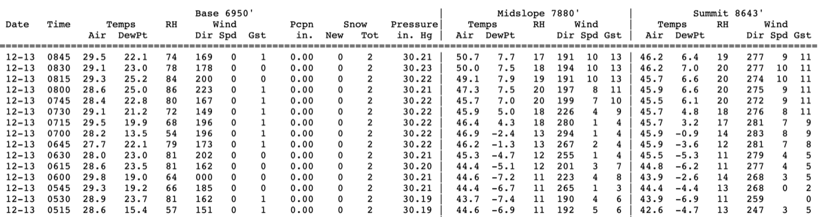
It’s been 28 degrees here almost every morning. Why is so little snow making going on? TLC???
The answer is temperature inversions. It was 18° at my house in Truckee this morning. The base area at Alpine got to 28° at 5am. But the top of Roundhouse never got below 45°. Being a bit lower, the top of Weasel was likely upper 30’s, which is too warm for efficient snowmaking. These inversions when we are stuck under a high pressure ridge are very misleading!
Thanks. Praying for Snow and at least colder temps.
Never too late to upgrade your Rose pass!
This is definitely not out of the question 😛
Snowmaking was happening with fan guns before 9 this morning, for what it’s worth. Looked like TLC and Dance Floor
Sweet!! Lower mountain had a few hours of temps…
FWIW firing up guns for anything less than about 3 hours is pointless. That being said it was nice seeing many mountain making snow way down low for that 4-6 hour window this morning. it’s been really really tough with these 100% humidity nights we keep having.
For reference, (for other readers, since Mark is already very well versed in the science of snowmaking) when humidity is 100% temps need to be at 28 or below for efficient snowmaking. at 50% humidity, air temp can be around 35 and create decent snowmaking. I personally have seen snowmaking occur around 40° when humidity was below 10% but that is pretty rare.
We need some wind to mix up this air and get the warmth and humidity to move on.
Do fan guns work as well in marginal temperatures? It seems as though Alterra/PTSVAM has invested in fixed fan guns on Exi/Weasel/Dance Floor over the past few years.
@MakeAlpineGreatAgain
In theory, snowmaking is dependent most on external conditions rather than the equipment used. However newer fan guns have clean nucleators that create smaller water droplets and can be more efficient. They also have on board weather and can auto adjust air/water ratios depending on conditions, and can be controlled remotely.
Bigger factors for snowmaking are water temp (the colder it is the more efficient you are) and water clarity (dirty water is better).
Places that use super clean water (Diamond Peak who uses municipal water that is pulled from tahoe (99.994% pure) then is further treated and chlorinated before being pumped to the mountain, struggle due to the water being too clean. No contaminants result in no points of nucleation.
But yes TL;DR newer snowguns should make snowmaking slightly more reliable during marginal conditions.
That guy is a treasure trove of knowledge!